SRT Selected for CIT CRCF Matching Funds Grant
March 10, 2019


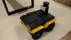
At the core of SRT’s M1 is a virtual map of every facility where we have deployed our system. The 2-dimensional base map of each facility is built by a robot, using a lidar to get a highly accurate representation of all walls, furniture, and structures within the facility. SRT’s original map building robot worked well as a prototype, but in order to improve the base map, we needed a better robot. This week, SRT received their brand new Clearpath Jackal. Sporting a SICK LMS-111 lidar, onboard accelerometers, GPS, and a magnetometer, SRT can now build even more accurate maps of much larger facilities. We look forward to integrating our mapping algorithms on this robot and taking her out for a spin!